
![]()
![]()
![]()
![]()
![]()
![]()
![]()
![]()
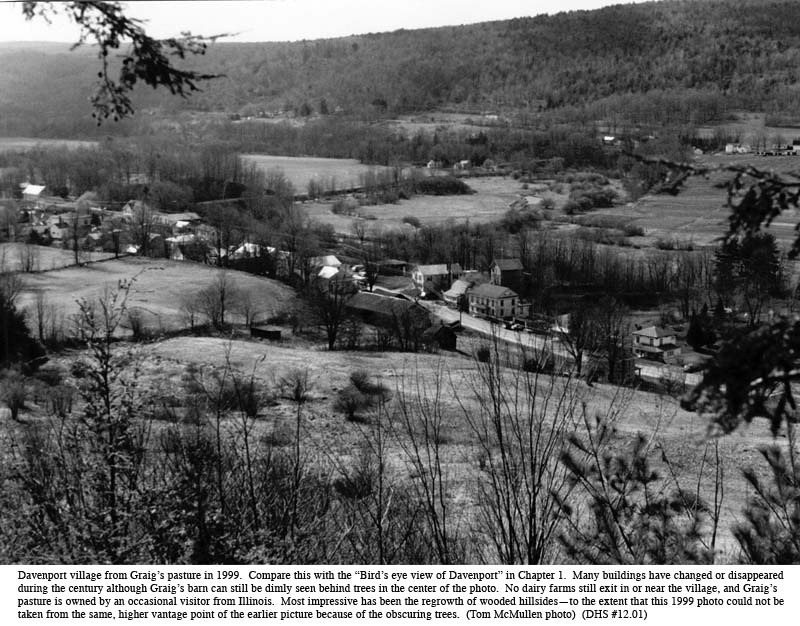
Davenport has lived through several major environmental changes within written history. The first followed the coming of the white man, particularly the settlement boom after the Revolutionary War. At this time agriculture and lumbering transformed the landscape and eventually led to the loss of much wildlife. A second major change came a century and a half later, following the Great Depression of the 1930s and World War II, when the hilltop and hillside farms all but returned to forest, and when turkeys, beaver, deer and bear returned to these new forests. This chapter will say more about these two major events as well as several minor ones.
Forest fires have been a continuous threat and an occasional danger, but their impact on the landscape has been generally short-lived, at least when measured in historical terms. They have already been touched upon in Chapter 8. Windstorms and tornadoes, to be mentioned only in passing, have been another periodic and destructive threat. The most serious of these in recent memory were the “twisters” of May 1983. “Several homes, barns, and garages were mangled and twisted as they were blasted with the high winds and twisters that accompanied the storm…” Especially hard hit in Davenport was the newly completed retirement home of Kurt Neunzig, the roof and ceiling of Lewis Garrison, and the upper level of Helen Osterlein’s barn, all on or near the Charlotte Creek Road.[1]
Floods and flooding, made worse by the earlier loss of tree cover, have been a more constant problem. They have precluded most permanent building in the flood plains and redirected the Charlotte River upon occasion. More dramatically, their real and/or imagined contribution to downstream flooding, in Oneonta and far-off Binghamton, provoked the greatest of all environmental threats to Davenport. This threat would itself have produced the greatest “flood” of all time, the man-made, permanent flooding of most of the town’s fertile agricultural lands from a proposed dam or dams in and above Davenport Center.
The last major environmental event to be touched on below was a rapid (in the historical sense) series of technological changes during much of the 20th century. Perhaps the most dramatic of these, affecting the opening up of the town, first to commercial agriculture and in more recent years to commuters and second homes, has been the automobile and the subsequent growth of the transportation system. Turnpikes and railroads were discussed in Chapter 4. These stories are continued below with the coming of government support for an improved secondary road system and, more recently, with major enhancements for the inter-town and interstate highway system.
Where did all the deer go? Daniel Patrick Moynihan drew attention to the first major changes noted above during a Fourth of July address at the Hanford Mills Museum in 1979. Senator Moynihan contrasted today’s abundance of deer and game with that described in the classic comment of Rev. Nathaniel Sumner and Mr. R. D. Miller, authors of the Davenport chronicle found in “Munsell’s” 1880 History of Delaware County, N.Y.:
The wild deer lingered
latest of the large animals. The
writer saw one on the hills in 1843, and tasted the venison of one caught in the
valley in 1845. The trout, that
yielded to the liquor from the tanneries, will return now that the bark is gone…
(Munsell, 1880, 143.)
It is hard for the modern reader to visualize Davenport’s physical and wildlife appearance one hundred and fifty years ago. A few old photographs show the surrounding hills almost bare of trees. We may have read that the polluted streams had once killed off almost all fish, especially the sensitive trout. We may remember, too, from our classroom lessons that the early pioneers would move west “when game grew scarce.” Yes, there once were elk in our valleys. Witness the two nearby “Elk Creeks,” one to the north in Schenevus and the other running south in Meredith from the Catskill Turnpike towards Delhi.
But some of the large game were already scarce by the time of the Revolution. According to the Conservation Department at Stamford, New York, most deer had gone from Davenport soon after the Revolution. Already in 1788, New York State required a closed season for deer from January to July. For a time after 1845 the season on deer was closed entirely. It opened again in 1929 for only a week.
Wild turkeys had succumbed to the settlers’ flintlocks (and a few of the new percussion cap guns) by 1845. Laws then protected the pitiful few still left. With turkeys, larger game, and most predators almost wiped out, squirrels and woodchucks thrived. “Wild rodents proliferated as they were liberated from the attacks of foxes, wolves, panthers and bears and as they found an increased food supply in the fields of grain that expanded as the forest contracted.”[7] The 1851 squirrel hunt reported in the Bloomville Mirror (see sidebar) was a well-established practice to limit crop damage. Taylor reports a similar, 1807 competition in Worcester in which one party netted 1,540 squirrels and one bear while the second boasted only 828 squirrels and a porcupine. A later hunt in 1820 claimed 5,383 heads.[8]
The
Bloomville numbers are even more astounding.
Note, however, that the quoted lead story appeared in one of the
newspaper’s very first issues. Could
it possibly have been subject to reader-attracting, editorial license?
Technical difficulties certainly existed and could have contributed to
the account’s extreme brevity and perhaps even to its somewhat vague
arithmetic. There was not yet a
printing press available, and mounted type had to be struck by a mallet against
each page.[9]
Tuesday,
June 17, 1851
The
Squirrel Hunt passed off in
fine
order on Saturday last. The count
stood
as follows:
Dr.
Leonard’s
Party,
29,410
John
H. McDonald’s party, 8,535
Amongst
the game there was 2,246
Squirrels,
419 Wood-chucks, 149 crows.
The
game actually killed for this hunt,
was
about 30,000!
But even squirrels (which in those days were defined to include “chip-monks”) and raccoons grew scarce as backwoods farms continued to be cleared and trees continued to disappear. The more marginal farms, especially on poorer soils and at higher elevations, themselves began to decline in the early 1900s. As recounted in Chapter 6, some were converted to dairying and survived. There was, too, a slowdown in the disappearance of small farms during the grim days of the Great Depression and the food scarcities of World War II. But the trend for many years has been downward, and many of Davenport’s hilltop farms have now reverted to poplar, beech and maple.
Deer
began to reappear in numbers after World War II.
Serious efforts were begun about 1952 to bring back the wild turkeys.
Though most died, there were some survivors among the 1200 turkey poults,
raised on game farms, released locally by the Conservation Department in 1952,
1953, and 1957. Dying trees in
newly formed beaver ponds signaled the return of that animal, but the first
visiting bear was not sighted until the last decades of the 20th
century. (A bear was reported shot
in South Kortright as early as 1960, but sightings did not become more frequent
for another twenty years or so.[10]).
By
2000, flocks of wild turkeys were well established throughout our area.
They could be seen in old fields and along wooded roadsides almost any
day—except, of course, during small game and bird season in October and turkey
cock season in the spring. The
white-tailed deer population had increased dramatically to the point of
exceeding forage capacity, partly because of a decline in the numbers of deer
hunters. Coyotes (see sidebar),
bear, bobcat and beaver are now observed at intervals, and there have been
convincing stories of panther sightings. Even
elk have been reintroduced to the south of Delaware County, in north central
Pennsylvania, and there is some talk of extending their range to the north.[11]
(Elk compete only marginally with deer for fodder.)
The sighting of eagles along the Charlotte River is no longer
newsworthy.
Floods and flooding.[12] Floods have always been a periodic threat to settlers and settlements along the Charlotte Creek. Nicholas Sigsbee, writing in 1889, remembered the great flood of 1812:
Nothing
like it had ever occurred before within the earliest recollection of anyone in
the valley. The water reached
across the whole valley [probably in the vicinity of the West Davenport home of
the Sigsbees] from one hill to another. There
were but few spots out of water on all the flats.
New channels for the creek were cut through solid flats in several
places. Holes were washed out of
the flats ten feet deep a quarter of a mile back from the creek.
On the lower part of what was lately known as the [John W.] Mickel farm a
channel was cut by the high water at least sixty rods [990 feet] long, about ten
feet deep and wide enough to hold all the water of any ordinary freshet in the
creek. Besides another channel was
cut directly across the Charlotte nearly a mile long, where the creek has
remained ever since, and making an island of ten or twelve acres.
(Sigsbee, 1889a, September 26.)
Most
current residents can remember recent years when the creek overflowed its banks
or even washed away structures, as when the bridge on Covered Bridge Road was
lost to the successive floods of
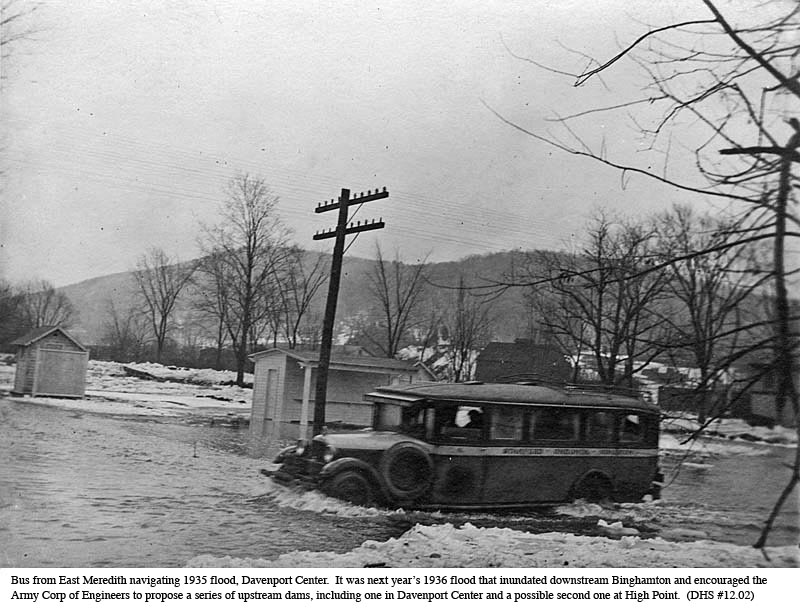
1935-1939. Floods at this time were
annoying annual events in Davenport Center and West Davenport.
Many were caused by ice jams in the area where Kortright Creek joins the
Charlotte River. Flooding
occasionally occurred twice in one year. One
time about 1945 a large barn was removed from its foundation.
People were taken to safety on tractors when necessary (operated by Henry
Doyle). Ralph Every rescued others
in his boat. One of the worst in
many years—perhaps a “150 year flood”—occurred on January 9, 1996, and
caused a reported $55 million in damages and seven deaths throughout Delaware
County.
In
most years and further upstream from Davenport Center, the local damage from
Charlotte flooding was relatively minor and perhaps even compensated by the soil
enrichment of farmers’ fields, but in 1936 a far-downstream
flood in Binghamton caused repercussions which confounded the valley for at
least the next 35 years.[13]
A direct result of the 1936 Susquehanna flood was new national
legislation and the authorization of seven new flood-control dams above
Binghamton. Two of these were
subsequently built: at Whitney Point and East Sidney.
Another, regarded as a key to the further upstream flood control, would
have been placed at Davenport Center.
Davenport’s dam battle. The Davenport dam, if built, would have destroyed the village of Davenport Center, flooded 3,000-plus acres of land, caused the destruction of over 500 buildings, and forever altered the shape and nature of the Town of Davenport. By one account the Davenport Center dam would be 121 feet high and stretch almost a mile across the valley.[14] Water from the dam might back up almost to the hamlet of Davenport. A later version of the project would have involved two dams, the second at High Point. This arrangement would have flooded 5-6,000 acres and backed the water up to Fergusonville.
Questions arose from the beginning about the value of such a dam or dams. The Charlotte’s watershed of 164 square miles represents only seven percent of the total Susquehanna watershed’s drainage area above Binghamton. Above Oneonta, the valley’s share amounts to only 27 percent of the total.[15] At best, flood control efforts at Davenport Center might reduce a flood crest at Binghamton by very little, perhaps by only eight or nine inches.[16]
When first proposed by the Army Corps of Engineers in 1936, the Charlotte dam met with little opposition within the valley, mainly because its exact location and dimensions were still uncertain. Plans were delayed by the advent of World War II. But in 1949, surveyors’ stakes appeared in the Cerosaletti farm in Davenport Center. Opposition to the dam began to gel, led initially by Davenport Supervisor Anker Norberg. Norberg reported that the “vast majority” of the community were “unalterably opposed to the project.” Norberg was at a loss, he told the Oneonta Star, why a minority of the town board, including former supervisor George Hillis, did not support the majority view.[17]
Despite minority misgivings, the local citizenry soon organized with a vengeance. Protests grew during the mid-1950s, rising and falling with the likelihood of dam-funding appropriations in the U.S. Congress. A meeting of 200 Davenport residents in February 1954 learned that New York’s Representative John Taber, chairman of the House Appropriations Committee, had given assurances that the necessary appropriations would not pass “this year.” In future years, the dam’s fate might depend on “strong action…taken by residents in the affected areas.”
The same meeting made permanent what had been a temporary steering committee to lead the fight against the flood control dam.[18] Residents, following the advice of Representative Taber, were urged to launch a “flood of letters” to their representatives in Congress and to New York Assemblyman Edwyn E. Mason.
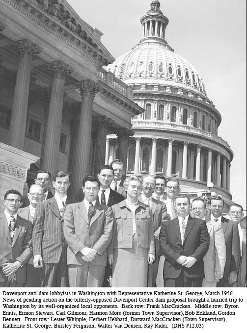
In March 1956, responding to the last minute discovery of a new appropriation threat, Davenport Town Supervisor Durward K. MacCracken led a 12-person delegation, including among others Clifford J. Eldred, representing the Oneonta Chamber of Congress, to Washington. The delegation met with Representatives Bernard Kearney and Katherine St. George who both subsequently opposed the dam.
The
dam threat was momentarily defeated but reemerged in the 1960s, supported by the
new Susquehanna River Basin Commission and with potential support from the New
York State Legislature. This time,
given the earlier difficulty in identifying sufficient flood control benefits,
the dam became “multi-purpose,” with the major portion of monetary benefits
derived from downstream “pollution dilution” (technically, “low-water
augmentation” or water quality control) and, most importantly, recreation.
It was about this time that a second (High Point) dam was added in one
variant of the new Davenport proposal. The
benefits of this second dam would derive entirely from recreation, most of which
was to be enjoyed by distant users.[19]
In 1969 the valley towns organized a Charlotte Valley Watershed Association with Charles Cerosaletti, also at that time a member of the Davenport Planning Board, as secretary and Ray Christensen as Chairman. The new Association helped to mobilize both public opinion and the efforts of local politicians, especially Assemblyman Edwyn E. Mason of Hobart (whose files have been especially useful in preparing this review.) At a public meeting in August 1969, Cerosaletti and Christensen claimed to have “70,000 votes to oppose the dam.”[20]
In addition to an enormous amount of public protest and behind-the-scenes politicking (see sidebar), experts were hired and articles published. The Town of Davenport employed Dr. Peter Black of Syracuse University, “an eminent Water Resources Specialist,” to prepare the critical 1970 report cited several times above.[21] Anti-Davenport dam articles were written and appeared in national publications, most notably the American Agriculturist (Christensen, 1969) and American Forests, the publication of the American Forestry Association (Kernan, 1969). Henry Kernan, a forester and lecturer at Cornell University who owned (and still owned in 2003) a 1200 acre tree farm in South Worcester, also presented testimony attacking the economics of a prospective 150 ton per day sulfate pulp and paper mill. The mill was being proposed to gain additional “industry and employment” benefits from the dam.[22]
Sometime before a public meeting was to be held in Oneonta, the Readers’ Digest had published an article that “took the Corps of Engineers to task.” The dam opponents asked for reprints, and when the Digest learned the nature of the upcoming meeting “they practically hand-delivered them—I mean they came like overnight with 1,000 copies and didn’t charge us anything. So there are a lot of things you can do if you use a little ingenuity…”[23]
Local
opposition was aided by the growing national recognition that big dams were
often less satisfactory, ecologically and economically, than they had once
appeared. In addition to high costs
and the loss of valuable valley lands, it appeared that some reduction of
flooding was occurring naturally through the decline over time of hillside
farming and subsequent regeneration of runoff-controlling woodlands.
In recent years there has even begun a reaction against government flood
insurance which in effect has subsidized residential and commercial building on
vulnerable flood plains.
|
|
The
real reasons for the collapse of Susquehanna dam-building pressures were
ultimately political. John Burns
had been the mayor of Binghamton and a strong early proponent of improved flood
control that would protect his city. Burns
was also the
chairman of New York’s Democratic Party and was able to enlist the powerful
support of Governor W. Averell Harriman and of then Senator (and ex-governor)
Herbert Lehman. The chairman of the
New York Department of Water Resources for a while threw his weight behind the
multiple-dam proposal for the Susquehanna as did, as might be expected, the New
York State Flood Control Commission.
Robert
Kennedy when he became New York’s junior senator in 1964 supported the dam
proposal and in 1965 sought $100,000 to step up further planning.
Numerous congressmen and women, mostly but not all Republican, opposed
the Susquehanna dams; Katherine St. George, John Taber, and Samuel Stratton are
the names that occur most frequently in the newspaper clippings from that era.
The
intensity of local opposition and the broader, growing objections to big dams
eventually persuaded Senator Kennedy to “give up the fight as not being worth
it.”[24]
Little has been heard since Robert Kennedy withdrew his support.
“In 1978 Jim
Hanley was our Congressman from Syracuse. He had enough clout in Congress
and we had access to [him]. That’s why it’s good to have both
Democrats and Republicans in your [corner] because someone can get to the right
door at the right time. And we did that and we got [the dam] deauthorized.
This was an exercise in bureaucracy and an exercise in politics, and it’s an
education for all of us, believe me.” (Charles Cerosaletti in
Christensen and Cerosaletti, 2001.)
Davenport
Center’s own ice-jam and flooding problem, the source of numerous newspaper
attention over the years, was largely solved by cleaning out channels and
replacing the old, road-level bridge across Kortright Creek.
The
motorization of America—and Davenport. From
the beginning of its settlement
Davenport’s physical environment has been altered by the trails and roads that
have gradually extended over much of the town.
The town’s human environment has been equally affected by the
introduction of the motor car (and truck) that accelerated road building and by
the series of other major technological inventions which characterized the 20th
century.
Social
life (and fire-fighting efforts) were transformed by the arrival of the
hand-cranked telephone in 1924[25]
although the original friendly, personal touch vanished when the central
telephone operator was displaced by the dial phone in 1939.[26]
Of similarly revolutionary impact, especially for refrigeration and
lighting, was the arrival of electricity. Although
some rural homes and farms did not receive power until a decade or two later,
most homes along the main thoroughfares were electrified in 1929.[27]
It
was the automobile and road expansion, however, that revolutionized almost every
aspect of village life. Included
were dairy farming (milk trucks and trailer-tankers), education (school busses),
employment (improved commuting for workers), rural mail delivery, fire fighting
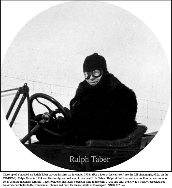
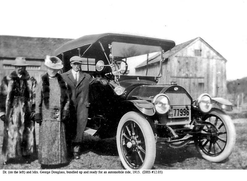
response, retail trade and deliveries, medical services (Dr. Thomas Craig in
1907 had one of the first autos in town), and eventually as agriculture
declined, even land ownership within the town. Not all changes were applauded by
the townsfolk. At the end of
the 19th century, Davenport was a scattering of farms and
self-contained rural villages, home to numerous retail establishments, small
factories, local craftsmen, lawyers’ offices, and even newspapers.
Under the impact of motorization, Davenport at the end of the 20th century
had become more of a regionally (if not a globally) dependent community having
few local-oriented businesses and far more commuters, seasonal visitors, and
summer vacationers.
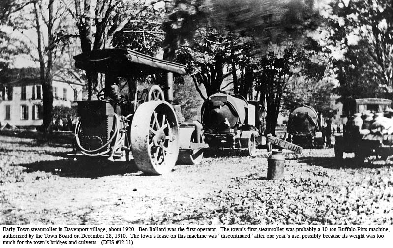
One
mark of the emerging automobile age was the increasing number of discussions at
Town meetings and the increasing amount of town moneys spent on road
improvements and road machinery. The
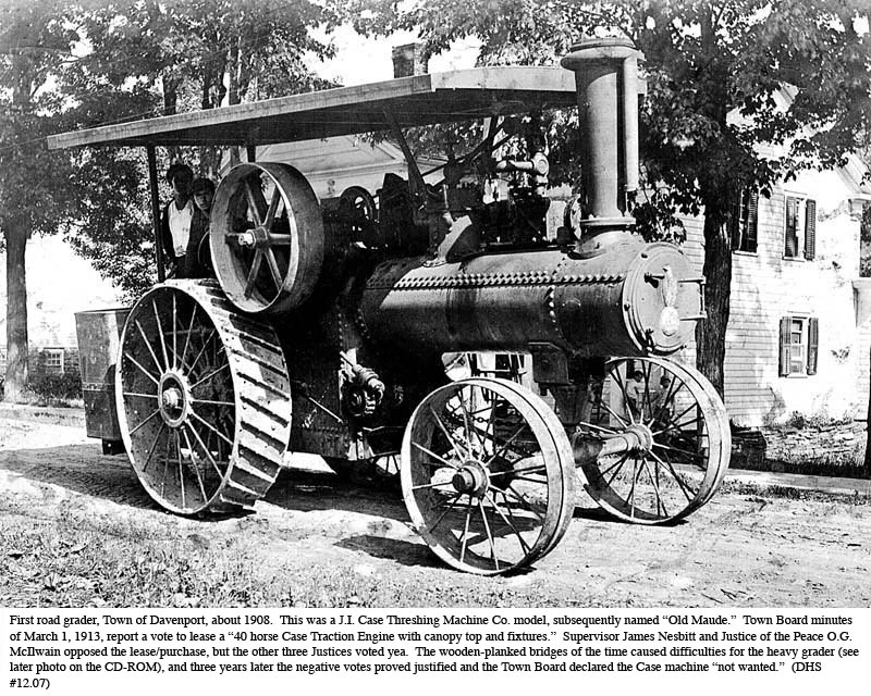
town leased a 10-ton Buffalo Pitts steamroller for the year of 1911 and in 1913
leased a 40-Horse Case Traction Engine over the negative votes of Supervisor
James Nesbitt and Justice O.G. McIlwain. A
Linn tractor (made in nearby Morris, N.Y.) was acquired sometime after World War
I and a 10-foot Adams grader in 1924. The
same year saw the purchase of a new Linn tractor (for $6,000), with a snow plow
($1,500) added two years later. A
Bay City gasoline shovel joined the Highway Department fleet in 1928.[30]
The
transition to motor vehicles in Davenport was nevertheless gradual.
The 1916 budget for the Superintendent of Highways allowed $300 for all
snow removal and one-third of that amount, $100, for watering troughs.[31]
The
dirt Charlotte Turnpike was graveled during the years before World War I,
following the purchase about 1913 of the Case motorized road grader (called a
“traction engine”), Davenport’s first piece of highway equipment.
It was later paved, bit by bit, in the 1920s.
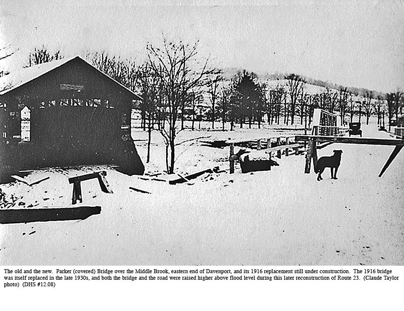
The new turnpike-road at that time crossed Middle Brook using the covered
bridge that until 1916 stood near the town’s eastern border.
In Davenport Center the turnpike still used a second covered bridge over
the Charlotte (at the end of what was later called Covered Bridge Road).
As
motor vehicle traffic increased, continuing improvements became necessary,
especially the Davenport Center bottleneck where the railroad crossed the
turnpike. Farmers were unloading
milk cans at the creamery, and fluid milk was moved onto cars bound for New York
City. Mail was being delivered, and
customers were arriving at Burdick’s Garage and at Ervin Davis furniture and
hardware store.
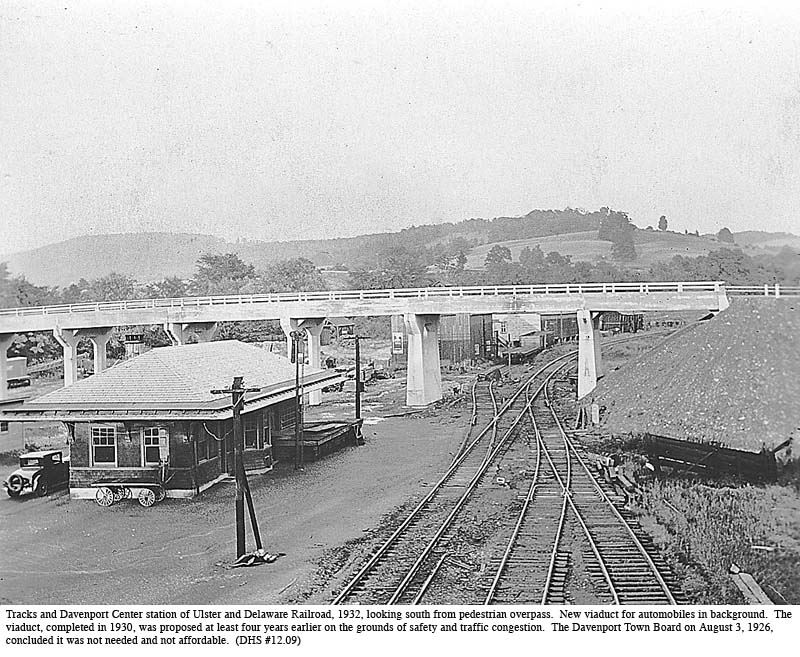
About
1930 the decision was made to build a viaduct over the railroad, thus avoiding
the dangerous road crossing. A new
section of road was then built between the Davenport Center Methodist Church and
the parsonage, linking to the viaduct. Shortly
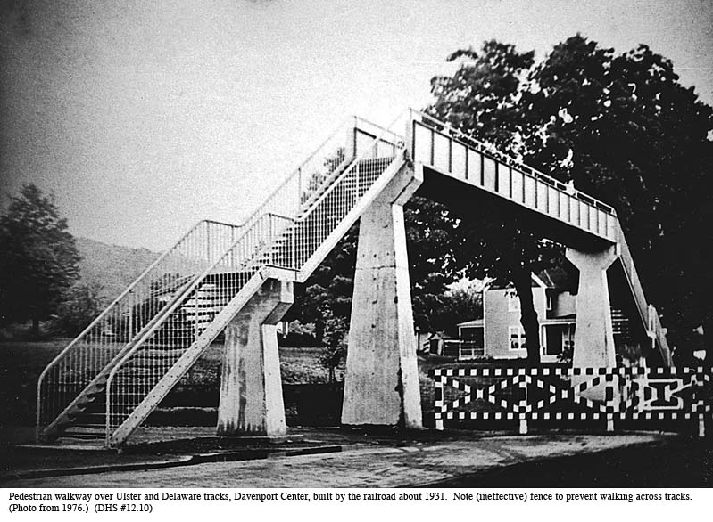
thereafter, in 1931, the Ulster and Delaware installed a high footbridge and
fence to prevent pedestrians from walking directly across the rails.
Though it has remained in place until this day, the footbridge was
chiefly used for photographs. The
steps up and down were formidable, and the railroad’s fence was easy enough to
walk around.
Meanwhile
America’s love affair with the motor car set record after record of car, bus
and truck ownership. Between 1910
and 1925, motor vehicle registrations doubled every few years.
The total numbers at the beginning of the Great Depression were twice
what they had been in 1922 and four times the number at the end of World War I.
Meanwhile the road builders struggled to keep up.
While motor vehicle numbers rose almost sixty-fold between 1910 and 1930,
surfaced rural road miles grew at only one-sixteenth that rate.[32]
The town of Davenport, as just mentioned, had no paved roads at all until
well into this twenty-year period. Total
road mileage in town increased almost seven-fold, from 13.14 miles in 1915 to 88
miles in 2003.[33]
In
1924 New York drivers for the first time had to apply for licenses.
A hand-cranked Ford touring car cost $295 although another $85 payment
would be needed for a starter and “demountable rims.”[34]
Construction
of both state and federally assisted roads progressed steadily throughout the
1920s and 1930s with a pronounced acceleration during the job creating days of
the 1930s. But supply could not
keep up with demand. Around major
cities, weekend traffic jams in the 1930s and 40s were far worse than anything
seen in more recent times. Road
detours and delays were frequent, automobiles and their tires were primitive by
today’s standards, and a long trip could take twice the time it would in after
years.
The
biggest changes occurred after World War II when Federal aid to highway
construction grew dramatically. In
1954, the federally-financed share of the Interstate System was raised from 50%
to 60% (state budgets paid for the balance) and then to 90% in 1956.
The 1950s saw the beginning of the limited-access, national interstate
and defense highway system, designated by the prefix “I” in place of the
former “US,” that transformed long distance travel for future generations.
As
far back as the late 1930s, under the push of public works activities and a slow
rearmament response to the rise of Nazi Germany, New York State had begun to
straighten and improve a number of Delaware County roads, including Davenport’s
principal east-west thoroughfare, Route 23.
(One of the first sections to be rebuilt was that of the long climb up
Windham Mountain from Catskill and Cairo, just west of the Hudson.
The older road in this section followed an alternative turnpike route
parallel to the eastern end of the Catskill-Susquehanna Turnpike.)
Route
23 between Stamford and Oneonta was in those days a long and winding road.
From Davenport village it took, in the motor cars of the 1930s, the
better part of an hour to reach either the village of Stamford or the town of
Oneonta. By 1939-40 the section of
Route 23 between Harpersfield and Davenport was rebuilt using stone from a
quarry in Davenport Center. (A
different company reconstructed the 8.3 miles between Stamford and Harpersfield.)
The rebuilding straightened out several curves and improved the grades,
especially through the George Hillis farm and above the “Boarding House”
farm near the eastern approach to Davenport village.
It also by-passed completely sections of the old road through Hoseaville
and in Davenport village and Davenport Center.
In early 1940, the Town of Davenport paved short sections of side roads
in West Davenport and Mill Road in Davenport.[35]
Route
23 construction came to a halt during World War II, and a short section to the
west of Davenport Center was further delayed by uncertainties caused by the
proposed Charlotte River Dam. By
1949, work from the western edge of the Center to Oneonta was resumed by a
company from Binghamton. Residents
near the western section of the road feared the new highway would be subject to
flooding, as their fields had been in earlier times (the old Route 23, now
Southside Drive, had been placed on higher ground) but no flooding problems have
occurred. Meanwhile, the one-mile
section where work was delayed by dam uncertainties has been repaved but, except
for the viaduct above Kortright Creek rebuilt in 1979, never updated.
(Robert Miller, the foreman for the viaduct contract, subsequently became
a permanent resident of the town.)
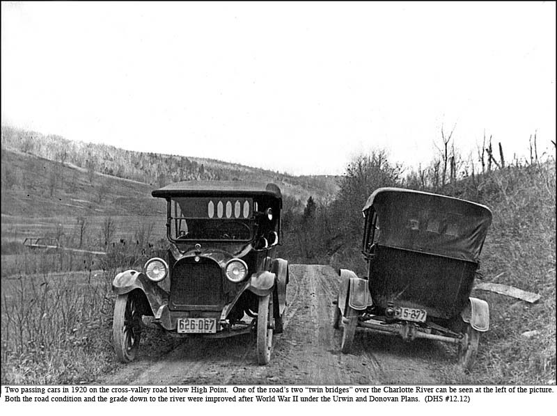
Modern
improvements to rural roads: the Urwin and Donovan Plans.
With the main roads much improved, New York State unveiled the Urwin Plan
about 1951. The purpose was to
upgrade the farm-to-market roads in rural areas.
The Plan provided Davenport with funds to widen and re-grade town roads.
Elmer Moore was the Davenport Highway Superintendent (1942-1975) at the
time. He and his men re-worked all
local roads over a period of years. The
Urwin Plan was followed by the Donovan Plan in 1974 to provide oil and stone for
improving the surface of local roads.
Even
before the Urwin Plan, the Town’s road crew had not been idle.
Machinery leases and purchases during the early 1900s, as described
above, had substantially reduced the former pick, shovel and wheelbarrow labor.
The Town even managed to acquire, for $6,625, a new L1nn tractor for in
1933. This last purchase
included a Depression-era arrangement allowing Davenport to benefit from any future
price drops throughout the life of the four-year payment plan.
Four years later, according to Town Meeting Minutes, Davenport added a
truck-and-snowplow and two 1938 Chevrolet dump trucks.
Other major purchases continued well into the years of World War II.
Work on removing embankments, straightening bad curves, and in some cases
abandoning roads that were too steep or hard to maintain continued throughout
the war. The hairpin turn on
McIlwain Road, a relic of the early-motor vehicle age, was eliminated in 1945.
.(The hairpin turn had been added to the old “Sexsmith Hill” road in the
fall of 1910 at a time when horses had an easier time with hills than
automobiles.[37])
The
friendly skies above.
At the end of the 20th century, Davenport was host to a
single, and little-known airfield owned by Charles Zimmerman off Parker
Schoolhouse Road in the east end of town. (The
airfield, actually, was just across the town line, in Harpersfield.)
This was a private airstrip, used by Zimmerman and his friends.
The
Zimmerman field was not the first in town.
In 1926, thirteen years after Earl Fritts had flown a bi-plane from the
Wilcox Flats and the Pony Farm in Oneonta[38],
an airplane was acquired by a Delaware County resident, A.H. Peaslee of Hancock.
The Whitlock “airstrip” in Davenport
Center was inaugurated within the following year as recounted by Delaware
County Historian, John Raitt:[39]
E. LaVern
Whitlock of Davenport [Center] had been rebuilding [in 1927] an airplane at his
home the past winter. He had purchased the plane the fall before. It
was a Canadian model powered by an eight cylinder Curtis motor. With
Carlton Hinman as pilot they flew down to Oneonta on Tuesday the first week of
May. Later in the afternoon they flew to Middlefield. The later trip
was made in 25 minutes.
In August, Roy
Tyler, a Hobart Merchant, was having an airplane overhauled at the Whitlock
field in Davenport. It was a Canadian Canunk with clipped wings powered by
a Curtis OX-3 motor. He planned to take the plane to the Oneonta airport
and there learn to fly it.
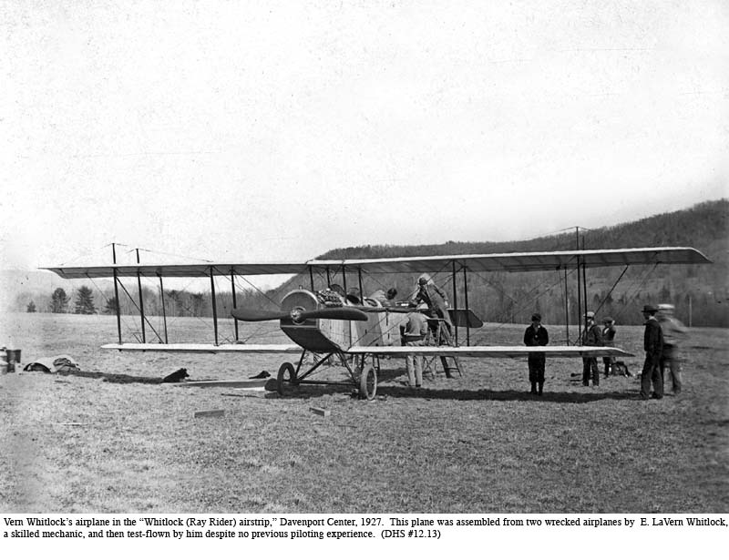
In
reality, the event was considerably more dramatic than the published account.
E. LaVern (Vern) Whitlock lived with his mother, two brothers and a
sister on a farm on Pumpkin Hollow Road. Vern
was physically handicapped but a talented mechanic.
He and his brother Dewey went to New Jersey to procure two wrecked
aircraft that Vern then combined into one.
There
was no room on their Pumpkin Hollow farm for a landing field, but Ray Rider had
just cut the hay on his field in Davenport Center (just east of the later Town
Hall and between the highway and the Charlotte River).
Ray (and everyone else) was curious about Vern’s plane so he allowed
the brothers to use the Rider field. Several
interested bystanders gathered as Vern tuned up the motor before the arrival of
pilot Carlton Hinman. Then,
without ever having flown a plane, Vern took off by himself toward Oneonta.
(This may have been a day before the “first week of May” flight
described above by County Historian John Raitt.)
Everyone was aghast. Not
only had Vern never flown, let alone landed a plane, but it was late in the
afternoon and getting dark. Ray
Rider and others called for cars to come and light the field with their
headlights. Vern “landed like a
bird,” reportedly thrilled.
Another
incident with early flying involved Jay MacClintock of East Meredith.
Jay was checking out his field of oats when the propeller of an airplane
rotated down from the sky in front of him.
The plane itself shortly followed. Someone
had secured the prop with copper wire. When
the wire got hot there was a problem.
Norman
Crandall and Ralph Every[40]
were two other local aviators. They
both owned their own planes and flew them from the small airport in Oneonta,
probably the D.F. Keyes Airport off Country Club Road.
The following additional illustrations to be found here.

| 12a |
Condition of Main Street in Davenport village, N.Y., about 1908. |
| 12b | Ice jam at Van Deusen Bridge, Middle Brook, Butts Corners, 1912. |
| 12c |
View of Van Deusen Bridge and Middle Brook ice floes, Butts Corners, 1912. |
| 12d | Ralph Taber and his first car, in the snow, 1914. |
| 12e |
Davenport’s “Old Maude” meets older Davenport Center bridge, 1914. |
| 12f |
The iron bridge over the Charlotte River, Davenport village, mid 1910s. |
| 12g |
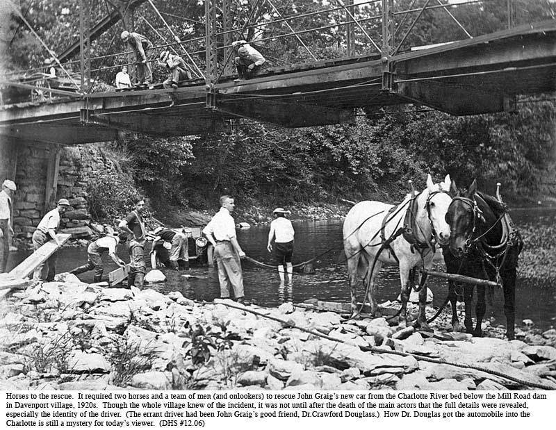
John Graig's new car below Mill Road bridge, Davenport village, 1920s. |
| 12h |
Decrepit car with long hood in front of decrepit building. |
| 12i |
Heavy traffic on Route 23 in Davenport Center, 1925. |
| 12j |
Davenport Center viaduct, built in 1930. |
[1] “Several homes, barns, and garages… on or near the Charlotte Creek Road. (Oneonta Daily Star, May 4, 1983, p. 1.)
[2] Sidebar: Richard Smith… “noted the… wolves, bears, elk, and especially deer.” (Taylor, 1995, 270.)
[3] Sidebar: Bears were a recognized pest… death of a little girl named Valentine in Harpersfield. (Munsell, 1880, 223.)
[4] Sidebar: Foremost was keeping the free-roaming buck sheep. (Davenport 1817 records quoted in Munsell, 1880, 144.)
[5] Sidebar: The 1803 bounty in Harpersfield… “occasionally renewed up to 1815.” (Munsell, 1880, 223.)
[6] Sidebar: The bounty fell to only $4… as wolves grew scarcer. (Reminiscences of Harvey Baker, ca. 1892, 172.)
[7] “Wild rodents proliferated… in the fields of grain that expanded as the forest contracted.” (Taylor, 1995, 289.)
[8] Taylor reports a similar, 1807, competition… A later hunt in 1820 claimed 5,383 heads. (Taylor, 1995, 289.)
[9] There was not yet a printing press available… struck by a mallet against each page. (Gould, 1856/1977, 401.)
[10] A bear was reported shot in South Kortright as early as 1960… (DHS Scrapbook, SCR-9, p. 56).
[11] The Rocky Mountain Elk Foundation in October 2000 filed for a “permit to release 100 elk—25 to 35 at a time—in the central Catskills.” Pennsylvania elk are reported to draw “at least $1 million in tourism dollars to a remote and mostly undeveloped area.” Some public hearings had already been held, and the next step at the time of the writing was to prepare an Environmental Impact Statement. (Catskill Center News, vol. 31, no. 1, Spring 2002, pp. 10, 12.)
[12] Floods and flooding. (This section draws heavily on materials from the Davenport Historical Center file,“Dav. Cntr. Dam Project,” and materials from Edwyn E. Mason, Raymond Christensen, Charles Cerosaletti, and others.)
[13] Davenport, according to a presentation by Christensen and Cerosaletti to the Davenport Historical Society (Christensen and Ceroseletti, 2001), also suffered flooding in 1935, 1936, 1937 and 1938. The 1935 flood caused the town to borrow $990, a large sum in those days “to repair washouts.” (Davenport Town Meeting Minutes, July 12, 1935.)
[14] By one account the Davenport Center dam would be… almost a mile across the valley. (Kernan, 1969.)
[15] The Charlotte’s watershed… amounts to only 27 percent of the total. (Black, 1970.)
[16] At
best, flood control efforts at Davenport Center… by only eight or nine inches. (House Doc. 500, 81st Congress, March 9, 1950, quoted in Assemblyman Lane’s 1970 briefing book, Davenport Historical Center.)
[17] Norberg reported …did not support the majority view. (Oneonta Star, March 18, 1949, from Scrapbook of Mollie Young, Davenport Historical Society.)
[18] The temporary committee had included Gilbert H. Cargin, Bursley C. Ferguson, Amenzo A. Merrill, Davenport Supervisor Harmon J. More, and William Rathbun. At the February 1954 meeting, according to the Star article already cited, Carl Schulz was added to represent the Grange and Michael Pizza to represent the Fire Department.
[19] The benefits of this second dam… most of which was to be enjoyed by distant users. (Black, 1970.)
[20] At a public meeting in August 1969… “70,000 votes to oppose the dam.” (Oneonta Star, Aug. 31, 1969.)
[21] The Town of Davenport employed Dr. Peter Black… cited several times above. (Christensen, 1970.)
[22] Henry Kernan… presented testimony … “industry and employment” benefits from the dam. (Kernan, 1967.)
[23] Sometime before a public meeting… a lot of things you can do if you use a little ingenuity…” (Ray Christensen in Christensen and Cerosaletti, 2001).
[24] The intensity …to “give up the fight as not being worth it.” (Conversation with Ray Christensen, Oct. 13, 2001.)
[25] See Chapter 7, sidebar on Davenport Hotel. This was a commercial venture, part of a regional system. Davenport had experimented with the newfangled Alexander Graham Bell contraption as early as 1899. The Davenport Standard of December 27, 1899 (by then a Supplement to the Schenevus Monitor—see Chapter 7), carried a few sentences under “Local Mention, Simpsonville” to the effect that “Mr. Davis of Bloomville has extended the telephone line from Davenport to South Worcester, putting instruments at Peter Davis’, Fergusonville, Mowbray’s Store…” An 1899 property assessment on the “Meredith Telephone Company “ was $625 for 10 miles of line in Davenport, and Davis’ telephone operation in 1900 was assessed at $250.
[26] …when the central telephone operator was displaced by the dial phone in 1939. (DHS, Scrapbook SCR VIII, 43.)
[27] …most homes along the main thoroughfares were electrified in 1929. (DHS, Scrapbook SCR-14d.)
[28] Acetylene gas was discovered by Major James T. Morehead and Thomas L. Wilson in 1892 and within “eight years the first carbide lamp was offered and soon after that, they were adapted for underground mining.” (“The History of Mining in Cape Breton—Mine Lighting, 1997, http//collections.ic.gc.ca/coal/tmine, 1/29/03.) “In 1898 the Union Carbide Company [its name today] was created in Virginia to manufacture calcium carbide for acetylene lighting.” (“Carbide—history,” http//www.endgame.org/carbite-history.html, 1/29/03.)
[29] Sidebar: “Carbide was purchased in bags … and could be used to whitewash a barn or shed.” (Briggs, 1983, 23.)
[30] The town leased a 10-ton Buffalo Pitts… gasoline shovel joined the Highway Department fleet in 1928. (Davenport Town Board Minutes Dec. 28, 1910; Mar. 1, 1913; Jan. 25 and Feb. 29, 1928; Feb. 10, 1926; and Dec. 28, 1928.)
[31] The 1916 budget.. and $100 for watering troughs. (Davenport Town Board Minutes, Nov. 10, 1916.)
[32] While motor vehicle numbers… road miles grew at only one-sixteenth that rate. (US Bureau of the Census, 1960, series Q252 and Q314.)
[33] Total road mileage… to 88 miles in 2003. (The 1915 mileage is from the Delaware County Supervisors’ Report of that year, page. 40. The 2003 total, from the Delaware County Planning Commission on February 1, 2003, includes 66.62 miles of town roads, 8.4 miles of Delaware County roads, and 13 miles of State highway.)
[34] In 1924 New York drivers… would be needed for a starter and “demountable rims.” (Davenport Historical Society, Scrapbook SCR 15b, p. 12.)
[35] In early 1940, the Town of Davenport paved… and Mill Road in Davenport. (Town Board Minutes, Jan 18, 1940.)
[36] Sidebar: Because of a blizzard and storms… North Kortright road for two weeks. (DHS, Scrapbook SCR 15b, p. 14.)
[37] The hairpin turn had been added to the old “Sexsmith Hill” road…(Davenport “Record of Road Work, 1901-1914,” p. 74; Davenport Historical Center vault.)
[38] In 1926, thirteen years after Earl Fritts… Pony Farm in Oneonta. (Frances Green and others, Arrowheads, Fences, and Iron Horses: A History of the Town of Oneonta, Bicentennial Committee of the Town of Oneonta: 1976, p. 22.)
[39]
The Whitlock “airstrip” in Davenport
Center … Delaware County Historian, John Raitt.
(Raitt,
1987, 144.)
[40] Ralph S. Every was a Davenport Justice of the Peace and member of the Town Board, 1930-1944.