
![]()
![]()
![]()
![]()
![]()
![]()
![]()
![]()
In many ways, transportation has shaped the life of the town of Davenport. The communication routes and the ensuing settlements along the Charlotte River and Middle Brook determined the geographic shape of the town. Before this, the Indian trails along the north sides of these streams brought travelers and what little settled life there was to the area. Later, the Charlotte Turnpike gave a great economic stimulus to the whole town. Still later, Davenport Center, nearby East Meredith, and West Davenport were benefited by the arrival of the Ulster and Delaware Railway. In recent times, motor highways and Interstates, up to and including I-88, have helped both to drain away and bring back population and businesses.
Non-happenings in transportation were possibly as important as the developments that did happen. What would Davenport have been like if, as once planned, the Albany and Susquehanna Railroad (later renamed the Delaware and Hudson) had come up the Schoharie Valley and thence down the Charlotte River instead of Schenevus Creek? What would the town have been like if the Ulster and Delaware Railroad, as originally intended and as shown on the Beers map of 1869, had come west along Middle Brook and then by way of the south side of the Charlotte? Or, had the Cooperstown and Charlotte Valley Railroad been extended beyond Davenport Center and up the Charlotte Valley? One cannot push these “might-have-beens” too far except to observe that they add a minor note of intrigue. They certainly reinforce the importance of transportation in the story told below.
Indian trails and rivers. Modern roads follow old turnpikes follow pioneers’ paths follow Indian trails. As many writers have asserted, this was markedly the case in the early lands of North America. One might add, furthermore, that Indian trails often followed animal paths and that these paths tended to skirt the shores of streams, creeks, rivers and larger lakes.
Two of the three major Indian trails in Davenport followed the northern shores of its two main waterways, the Charlotte River and its chief tributary, Middle Brook. There was probably also a roughly north-south route that possibly cut across South Hill from Schenevus Creek to near the Butts Corners of today. This third trail then climbed the valley wall, perhaps along the present McIlwain Road, and continued across the relatively level land to the present Doonan’s Corners and thence to the Delaware near today’s Bloomville.
The routes along the Charlotte River and along Middle Brook were undoubtedly sections of longer trails used for distance traveling by the Indians. There were surely, too, shorter and more local hunting trails within the town of Davenport. After all, arrowheads and other artifacts have been found in many places. But, as already noted, the town-to-be did not see any heavy or even permanent settlement either by the Indians or the earliest European wanderers.
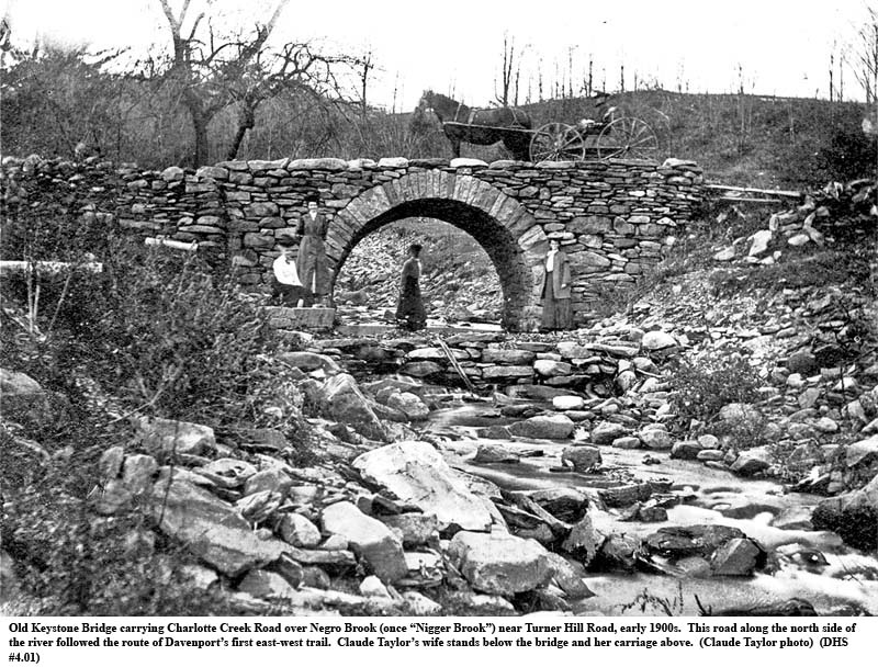
Existence of the Middle Brook trail, the present Route 23 east of Butts Corners, is inferred from the fact that its terrain provides relatively easy east-west access and that the route was certainly used by early white settlers traveling westward from Harpersfield. In Munsell we find, for example: “The travel along the north side of the Middle Brook made it necessary that the first bridge in town should be across the Charlotte, just above the junction of the two streams.”[1]
The trail along the upper and lower reaches of the Charlotte River is better documented.[2] This trail shows clearly on the October 1778 map made by William Gray. As noted in Chapter 2, Captain Gray had accompanied Colonel William Butler’s punitive expedition to the Indian town of Onaquaga on the Susquehanna.[3]
The same map, with its several inconsistencies, provides evidence, too, for the north-south trail through Davenport, the only one of the three that does not appear to follow a major streambed. This trail begins at “Youcham” (also “Yokeums,” a corruption of Joachim VanValkenberg) at the mouth of Schenevus Creek. It is shown first to ascend and then to cross South Hill, diagonally, to below the Servoss place, perhaps about the present Fergusonville. From there it passes the house of John Parks, for whom we have no other record, then “Middle Creek,” partly misplaced on the map, then to the house of John Morrow before crossing “Aleout” (Ouleout) Creek below “Harpers.” The trail then continues south to “McCashlands” and down what is without doubt the present Wright’s Brook to Bloomville. (An alternative north-south trail could have followed the route taken by the later road and mail route from today’s Cooperstown Junction up and crossing South Hill near the nameless mud pond and bog now owned by Hartwick College. See Chapter 13. This old trail and road—since abandoned—then descended to Davenport Center near the present Pine Lake.
Gray’s map was probably based in part on hearsay (sidebar). It is certainly wrong in detail, although there probably was an old trail of the general direction indicated, going by the places shown on the map. “Aleout” Creek in reality was probably not Ouleout but Kortright Creek, which drains from the direction of North Kortright and Harpersfield. One later analyst interprets “McCashlands” as the Scot settler Dougal McAslin, located near the current Braehead Hill road in Kortright.[4] This road leads through the hills towards the house of John Harper (leads to that house in the Gray map, another likely error).
Judging strictly by topography and ease of travel, it seems most likely today that the north-south trail shown on the Gray map did not cut diagonally up and over South Hill. Instead it would have gone up Schenevus Creek for some distance until it could more easily pass over South Hill to Fergusonville along one of today’s town or county roads. The trail may even have passed over the hill on today’s Parks Hill Road, and that road in turn could conceivably have been named for the family of the early John Parks of the Gray map.
From Fergusonville, the Indian trail most likely dropped down the Charlotte to the Middle Brook intersection near the present Butts Corners, crossing Middle Brook on the way. It would have then continued south and southeast, crossing the uplands and proceeding in a fairly direct fashion to the vicinity of the present Doonans Corners or Kortright Center. Certainly this last section seems to have been that followed by the pre-Revolution Scotch community, located in the 10 to 12-mile stretch between Fergusonville, Butts Corners and Bloomville.[5]
River and streams, as it has been noted, often encouraged trails along their banks. The larger ones also provided direct transportation by water. We have seen how the 1723 Palatine migrants followed the Charlotte downstream to the Canoe Place, then built canoes for the trip down the Susquehanna. That river, of course, provided a far more effective means of transporting goods, though even then there might be problems with low water conditions, rocks and sand bars. Further upstream it took a man-made torrent in August 1779 to float General James Clinton, his 1600 men, supplies and armament down the Susquehanna from Cooperstown.[6]
It is not likely that Indians or settlers kept canoes on the Charlotte for ordinary use. The river, even though possibly higher than at present, would have required careful navigation, and for light loads in most circumstances the journey would be swifter along its banks.
Paths, turnpikes, and roads. Davenport’s “roads” were in a primitive state in 1817 when Stephen Olmstead, Conrad Burgett, and Joseph Goodrich were elected road commissioners. Indeed, roads as we think of them today were non-existent. Crude paths followed the old Indian trails along some waterways. These could be used only with difficulty for the movement of goods in wagons. Some early settlers of course arrived with their families on foot, all their worldly goods on their backs.
Paths had been gradually improved since Indian times. In 1787 the state legislature decreed that the Commissioners of Highways should “open and extend all public roads ‘to the extent of two rods [32 feet] at least.’”[7] Each county was to have one commissioner and each town, three.[8] The town’s commissioners divided the town and issued warrants for each road district in which one man, the pathmaster, was to act as local overseer. A pathmaster would make a list for his “beat” of the property owners and the number of days each was required to work on the roads each year. The size of farm and the condition of the owner determined the road maintenance and improvement obligation. Widows might pay a fine instead.
The property owner-worker might have to supply a horse or stone-boat (sledge). If unable to work on the road, the property owner was to pay personally someone to work in his place. Wagon roads were especially poor in spring with ruts and mud, and in 1801 the legislature specified that at least half of all workdays be before the first day of July.[9] Neither town nor county money was provided until many years later for road repair or improvements.
For the new territories it was essential to develop some form of roads into the hinterlands to reach trading posts and to barter with Indians, trappers and homesteaders. Peter Smith, both a friend and at one time a land agent of Sir William Johnson, had once operated a trading post at the town of Catskill. He knew the needs of trappers and hunters, as well as of the fur traders, one of whom, later a partner of Smith in the ownership of the Charlotte River Patent[10], was fur trader and future tycoon, John Jacob Astor. With immigration increasing as well, the old Indian trails would no longer suffice.
The practice at the time was to include extra land, usually two acres for each prospective lot, with the original patent and later in the sale or lease of each farm. This extra land was to be used for a road to one’s neighbor. Much can be learned about the web of roads by tracing the records of local Commissioners of Highways.
For other than local or minimal roads, hard cash was needed to hire men, teams, and wagons. Public lotteries were used at first to raise funds, but the predominant method in the early 1800s was to form a private turnpike company. These were chartered by the New York State legislature, allowed to raise whatever funds might be required, and operated for the profit of the turnpike owners and investors. By 1806, a later study revealed, 67 turnpike and road companies already existed in New York State. Twenty-eight of these turnpikes had been more or less finished by 1806. Ultimately, only 35% of all proposed and planned roads would be completed.[11]
By 1812 three major east-west roads crossed Delaware County from the Hudson River. The history of Davenport is bound up with two of these, the Susquehanna turnpike (also known as Catskill) and the trail that later became the Charlotte turnpike.
After the Revolution, a great wave of emigrants made their way into the relatively unpopulated patents. New settlers, some staying and some moving further west, began following the old trails west from the Hudson through the Catskills, and on the Susquehanna and beyond. “By an act passed April 6, 1790, the Commissioners of the Land Office were ordered to explore, buy out and open a road from the Susquehanna River at the mouth of the ‘Oulehoudt’ [Ouleout] to the Schoharie Kill and thence to the Hudson River, pursuing the present tract of communication now between said rivers.”[12]
Sluman and Nathaniel Wattles, of Scotch origin, had come as surveyors to the Ouleout Creek in 1782, probably following the old Indian trail from Harpersfield. Judge Sluman Wattles settled in what became Franklin in 1784 and in time became one of the new town’s leading citizens.[13] The family and the presence of a growing settlement in that part of the wilderness undoubtedly influenced the location of the road to what had become known as Wattles Ferry (and later, Unadilla). Nathaniel Wattles and Medad Hunt contracted for 680 pounds to open and make the authorized road from the Hudson as far as Stamford by 1792.[14]
Both Nathaniel, with whom “Wattles Ferry” is associated, and Sluman Wattles worked on the road and welcomed the further upgrading, especially of the final stretch past Stamford, made possible when the Susquehanna Turnpike Company was formed in 1800. (Both Sluman Wattles and patent-owner John Kortright were charter members of the new company.[15]) Although undertaken with dispatch, the upgraded toll road still had not progressed beyond Stamford by 1802. In the following year the directors accepted bids for the “residue of the Turnpike Road” through Harpersfield, Kortright, Meredith and Franklin. This final section was probably not finished until sometime between 1803 and 1806.[16]
This
[turnpike toll] road passed through the entire length of the town of Franklin,
from west to east, and brought a great deal of money into the town.
Hotels were built every few miles, and were usually full of guests, night
and day, it being no uncommon occurrence for thirty to fifty travelers to stop
for a meal of victuals or to spend the night, usually merchants from the west on
their way to Catskill or New York. Immense
covered freight wagons with wide tires, drawn by six or eight horses, were
constantly on the road. (Munsell, 1880, 178.)
“In 1805 it was reported that the stock of the Susquehanna Turnpike Road Company was in the hands of two or three wealthy individuals, and that the road was wholly in operation and was paying five percent on the stock.”[17] Toll roads were lucrative enterprises. Settlements along them grew rapidly.
The Town of Franklin[18], at the western terminus of the turnpike, contained 1386 persons in 1800. By 1810, after the turnpike’s completion, the population had grown by almost one-fourth to 1708. A far bigger growth spurt occurred during the 1810-1820 decade when the population climbed by forty-five percent to 2481. For Harpersfield, further up the turnpike, gains came sooner. Population grew by a robust two-thirds, from 1003 to 1691 inhabitants, between 1800 and 1810 and then slowed over the following decade. The population growth of Kortright, on the turnpike between Harpersfield and Franklin, is more difficult to assess because it included much of Davenport’s population in 1800 and 1810. Kortright’s population increase, nevertheless, was probably even greater than that of Harpersfield, roughly doubling over the decade. Meredith’s inhabitants, in turn, more than tripled (from 237 to 726) from 1800 to 1810, and rose a further ninety percent in the next ten years.[19]
The new turnpike was obviously a boon to local developers and real estate agents.
There was even a spillover effect on Davenport.
This town was not directly on the Susquehanna/Catskill turnpike—the
turnpike passed to the south of Davenport by a minimum of 2-3 miles, but access
to Davenport from the east was certainly improved via Harpersfield and Kortright.
Population in the area that became Davenport had exploded during
1790-1800, from perhaps about 60 to over 400.
It may have almost doubled from 1800 to 1810. It
likely increased by a further forty percent between 1810, when it was still
mostly incorporated in Kortright, and the year 1820 after it had become a
separate town.[20]
In the next ten years there was further growth of almost thirty percent.
Thus the turnpike appears to have had a formative impact on the new town,
particularly in contributing to the early rapid growth that led to Davenport’s
formation in 1817.
The coming of the Charlotte Turnpike. Timothy Dwight, president of Yale, passed over the Susquehanna-Catskill turnpike for his second time in 1815 and spoke disparagingly of its deterioration. (See below under Stages and Inns.) His comment was a portent of things still to come. As Dorothy Kubik describes it, “Probably no one anticipated the volume of traffic that would flow over the turnpike in the next twenty years. The constant movement of stagecoaches, heavily loaded wagons, and thousands of animals completed the damage inflicted by the weather. In an effort to lessen the destruction, the General Turnpike Act of 1807 gave lower toll rates to wagons with six-inch [wide] wheels, and free passage to those with twelve-inch wheels as they damaged the road less than more narrow ones.”[21]
Meanwhile other population centers were growing, including the new settlements of Davenport and, on the banks of the Susquehanna, that of McDonald’s Mills (later Milfordville and eventually Oneonta). In 1803 when traveling east from McDonalds Mills to Catskill, it was apparently easier to join the Catskill Turnpike by first “making a tortuously slow journey down the north bank of the [Susquehanna] river on an overgrown trail” than by following the probably even cruder trail up the Charlotte River to Kortright.[22]
Meanwhile, too, the ubiquitous Peter Smith, now a half-owner of the unsold sections of the Charlotte River Patent, began to agitate for a better road along the Charlotte. Such a road would greatly increase the value of his holdings, especially on the south side of the river where no proper road then existed. On McCalpin’s 1808 map of New York State turnpikes, an “Albany and Delaware T P R [Turnpike Road]” is shown as running down the south side of the Charlotte, but that road, like so many others, was never built.[23] In 1811, Peter Smith offered to contribute $500 to anyone who would start a stock company for constructing and operating such a road.
In 1830 the town of Oneonta was formed from Otego, Huntsville and Milford. Led by Oneonta merchants E.R. Ford and William Angell, a charter was obtained for a Harpersfield-to-Oxford[24] turnpike road to pass down the Charlotte from North Kortright through East Davenport, Davenport Center, and Oneonta. (Oxford is about 27 miles west of Oneonta.) The charter was granted in the winter of 1834. Ford wanted the new road to continue on the south side of the river and then to cross the Susquehanna so as “to pass by his store and business down town. Angell wanted it to come where it was finally built,” that is, crossing the Charlotte before West Davenport and on the north side of the river to Emmons, “so as to pass his hotel and property.” Angell prevailed, “and the turnpike was built in the summer of 1834 by one White of Prattsville.”[25] The turnpike generally followed the current State Route 23 from Harpersfield as far as the Davenport Center turnoff. One tollhouse was located near the Harpersfield Town Hall and the second was next to the cemetery in Davenport Center.
The coming of what became known after 1834 as the Charlotte Turnpike had major effects locally. It hastened the demise of the Susquehanna Turnpike by providing a shorter and easier route to the Susquehanna, to the growing town of Oneonta, and a faster link to the Cherry Valley Turnpike and then to Albany.[26] In April 1842, the Commissioners of Highways in the towns of Harpersfield, Kortright, Franklin, Meredith and Sidney ordered that the Susquehanna Turnpike between Hotchkiss Mills in Harpersfield and the Susquehanna River be transformed into public road districts. The order marked the end of the Susquehanna Turnpike to Wattles Ferry.
The test of any turnpike was in its use. New settlers were arriving weekly via the combined Catskill and Charlotte turnpikes. There must be inns and taverns to care for travelers and drovers. Tradespeople and salesmen were introducing new ideas with the inns as meeting places. In Dudley M. Campbell’s 1906 History of Oneonta:
After its completion this road [the Charlotte Turnpike] became a great highway from the Susquehanna River to the Hudson River at Catskill, both for stages and teamsters. For many years nearly all the goods that came to country stores hereabouts and all the lumber that went from here to the Hudson were carried over this route…The Charlotte Turnpike was also the road taken by cattle drivers from the west. It was not an unusual sight to see several droves of cattle, a thousand or more in a drove, from Ohio and Indiana, as also large flocks of sheep, pass through the town [Oneonta] in one day during the summer season… (Campbell, 1906, 89.)
The new turnpike, as the Susquehanna turnpike before it, spurred commerce and contributed to local population growth. Salesmen carried new ideas back and forth. Davenport’s population rose by one-third in the ten years, 1820-1830.[28] In the 1830-1840 decade of the turnpike’s arrival, the town’s inhabitants continued to increase at this rate, but population growth in Franklin stayed at a low 9 percent and that in Kortright, Meredith and Harpersfield actually fell. (By comparison, in the nearby town of Maryland, not affected by either turnpike, population increased by 22 percent between 1820 and 1830 and by only 5 percent from 1830 to 1840.)[29]
The overall impact of the Charlotte Turnpike, summed up in a town history of 1880, ranked only after nature (particularly with respect to the early settlers’ abundant waterpower) “in controlling the destiny of the town.”[30]
Stages and inns. The roads and turnpike story is not complete without some mention of the excitement of early travel and of life along the new roads. One early account comes from Timothy Dwight, president of Yale, who traveled over the road in 1804 on his way to Niagara. (The alternative stage route up the Mohawk Valley, according to Kubik, did not reach Niagara until 1812.[31]) Dwight made the journey in about three days but was not overly impressed either by the road or the settlements along the way. Jefferson and Stamford were mostly forest. “I can scarcely conceive that an agreeable residence will ever be found in either of these places.” Harpersfield was more noteworthy and “a settlement of some standing.” Houses there were better and the church had a steeple, in that region a singularity. Neither schoolhouse nor church was seen in Kortright. In Meredith, Dwight found rich soil, poor water and a 247 foot fallen pine tree. After Meredith the country “lost its beauty.”[32]
Dwight refers to the taverns on the road, which he calls inns, “because each of them hung out signs challenging this title.” But he says the signs were liars, as the places were mere dram shops, spreading “little circles of drunkenness throughout the state.” The road from Catskill to Wattles’ Ferry, he said, was well made, “but passes over ground too uneven to be pleasant.” Dwight passed over the turnpike again in September, 1815, and says the road was very bad and had been long neglected. (Monroe, 1949, 91.)
Despite shortcomings, the turnpike remained for many years the principal mode for transporting farmers, immigrants, public officials, traders, freight, mail, and livestock, back and forth through the Catskills and Delaware County. Michael Fletcher and his son, drovers, used the turnpike to move cattle, sheep, hogs and turkeys from farms to the Catskill Turnpike and on to the Hudson River where they were loaded on boats for New York City. Stagecoaches ran the distance several times weekly. In 1825 “a coach left Catskill for the west every day but Monday.”[33] Farmers “with their wagons full of wheat, oats, flour, whiskey, cheese and firkins of butter found themselves competing with stagecoaches for a place on the turnpike.”[34]
Ah yes, the livestock:
Dealing in livestock seemed a profitable business, except the only way to get the animals to market was driving them on foot the whole distance, whatever it was. As a result, residents along the turnpike could expect to see, especially in the fall, whole herds or flocks of cattle, pigs, sheep, and turkeys pass by their doors at any one time, sometimes 1000 sheep and 500 “horned cattle.” And travelers could count on being held up by the plodding mass that must have filled the width of the road. Sometimes these slow-moving travelers backed up traffic for a mile, especially when they had to go though the tollgate and be counted and paid for. (Kubik, 2001, 75.)
Not the least important freight was the mail. With the first franchise in 1805, mail went to Delhi, Franklin, Kortright, Harpersfield, Meredith, Middletown and Stamford. Before that, messages were hand carried by travelers, occasional post-riders, or friends. Mail would be left in care of the innkeeper to be picked up or carried onward by someone passing the home of the addressee. (The hamlet of East Davenport had a twice-weekly, house-to-house mail delivery as early as 1829.[35]
When mail routes were established and mail stages franchised, the mail was carried to specific destinations with no stamp. Payment was made upon delivery. The mail was usually transported under the driver’s seat, at first once a week. By 1837 it was twice a week, at least on some sections.[39] Mail time attracted people to inns to pick up mail, visit neighbors and friends, catch up on news, be introduced to new ideas, and conduct business.
No one knows exactly how many stage lines were in operation altogether and over time on the Catskill-Wattles Ferry or Charlotte Valley routes. Because of an act of March 28, 1805 (12 years before the town of Davenport was created), we do know some details of one early arrangement. David Bostwick and others were given an exclusive franchise for seven years to operate a once-a-week, Catskill-to-Unadilla stage line. The fare for the three-day trip was to be no more than five cents a mile per passenger and five cents for each 150 pounds of extra baggage. Fourteen pounds were allowed with no charge. Any competitors would be fined $50.[40]
A pair of horses drew the first stagecoaches. It may not have been until 1820 that the much larger four-horse stages appeared on the Catskill-Susquehanna turnpike.[41] These were the great vehicles whose drivers became the objects of story and legend. The choice of drivers was of prime importance for a successful stage line in the heyday of the big rigs. The drivers must be polite to customers and drive carefully over rutted roads. They must be honest about turning over monies collected. They must carefully tend the horses, keeping them well shod.
In 1891, Jesse Haynes was a blacksmith in East Meredith. Over his many years of shoeing horses he shod many used for stagecoaches. He said they were unusually big, tough horses. Sometimes he had to snub the horses to a pole for shoeing. On occasion he actually had to throw the horse and have his son, Charlie Haynes, sit on the horse’s head to complete the job.[42]
The drivers must of necessity have been strong and skilled, experts at handling four-horse teams through slush, snow, storms and, perhaps even more dangerous, fog. The driver might have to lead his huge animals by hand through a quagmire. In some places the Susquehanna Turnpike took a fairly direct route across country, largely ignoring hills. Up and down the road went, and the coaches’ speed down some of the slopes could become formidable.
The mighty four-horse stages seem to have lasted into the 1870s, when railroad competition accelerated the turnpikes’ decline. Smaller, two-horse coaches at first replaced the many-passenger, four-horse vehicles. Then these, too, eventually disappeared from the roadways.[43] Interestingly however, and for reasons actually related to the coming of the railroads, stagecoaches in Davenport reappeared and continued on the old Charlotte Turnpike well into the next century. (See below.)
Taverns and inns of questionable quality were in abundance, “one per mile” some said, along the Susquehanna Turnpike. Beginning in 1797, licenses were used to control these businesses. Huge quantities of whiskey were consumed. In 1798, eight tavern licenses were issued in Franklin alone. Franklin’s first distillery was built in 1810 and a second, in 1812. Thousands of barrels of whiskey were produced. The taverns consumed their share of the plentiful supply. Much was carried first to the Delaware River and then by raft to Philadelphia, 100 barrels per raft. “A great deal of liquor was drunk in the town and vicinity, and there were but few families but what kept a sideboard well stocked with the same, which was freely offered to all visitors, as well as used in the family…Large quantities of cider were afterwards made at these old distilleries.”[44]
With the eventual demise of the turnpikes and stagecoaches, the days of the taverns also ended. “The turnpike made the taverns because without it, the taverns would have had no purpose. Likewise the taverns made the turnpike because it could not have fulfilled its purpose without it.”[45]
The coming of railroads. The age of turnpikes was followed by the (brief) age of canals and then, for the better part of a century in Delaware County, of railways. The opening of the Erie Canal in 1825 gave a dramatic boost to east-west freight traffic through New York State. It also drew traffic from the turnpikes, beginning the decline that was to become final with the coming of the railroads. The canal’s impact in areas south of the Mohawk Valley led to cries for government help to improve, too late, the east-west turnpikes in those parts and, later, in promoting east-west railways.
The Catskills’ Age of Railroads began after the Civil War, in the 1860s. Three roads in particular influenced Davenport’s economy and growth. These were the Albany and Susquehanna, the Ulster and Delaware, and the Cooperstown and Charlotte Valley.
The impact on Davenport of the first of these roads was negative. The Albany and Susquehanna (later the Delaware and Hudson, or D. & H.), was completed from Albany to Unadilla by 1866 and to Binghamton by the end of 1868. It had been originally planned to pass down the Charlotte Valley, the right-of-way from Albany first ascending the Schoharie valley via the old Indian route described earlier in this chapter.[46]
John Westover of Richmondville was one of thirteen directors of the Albany and Susquehanna Railroad Company, incorporated in 1851. Other directors included J. Pierpont Morgan and James Rosevelt [sic] of New York City.[47] The original routing would not have gone near Richmondville, and Judge Westover, a large landowner, was able to persuade the railroad officials to redirect the road through Westover’s community and down the Schenevus Creek rather than down the Charlotte Valley.[48] This left Delaware County with no real commercial outlets. Richmondville, Worcester, Schenevus, Maryland, and Oneonta prospered. Davenport remained in the backwater. Younger men moved to Oneonta for more lucrative employment.
About the same time, another railroad was being constructed that eventually would have a more positive effect on Davenport when it finally reached the town in 1899.[49] This began as the Roundout and Oswego Railroad, chartered in 1866 and designed to go 106 miles through Davenport, among other towns, to Colliersville where it would connect with the Albany and Susquehanna.[50] The railroad over the years experienced several name changes and reorganizations. It was the New York, Kingston and Syracuse Railroad that finally reached Stamford in 1872 and helped that village become for many years “The Queen of the Catskills.” The roadbed in the same year was cleared beyond Harpersfield on its way to North Kortright, Davenport, Davenport Center, West Davenport and Oneonta.
The Ulster and Delaware, however, was not to reach any part of Davenport for another eighteen years. In 1866, anticipating the arrival of rails, stations and trains, the town had appointed a new set of two Railroad Commissioners (previous Commissioner appointments were on behalf of the Albany and Susquehanna). With the long delays, both the new and the old commissioners had little to do. The last record of a Davenport Rail Road Commissioner is an eight dollar payment to William (“Uncle Billy”) McDonald in 1875.[51]
Meanwhile, a controversy had erupted over the railroad’s route past Stamford. Six miles of grade had been cleared towards Harpersfield, and the expectant citizens of that town had already advanced $100,000 to the old Roundout and Oswego. Nevertheless management of the newly reorganized N. Y., K. & S. decided it would be more lucrative to skip Harpersfield and serve the productive dairy regions of Hobart and Bloomville to the southwest before proceeding to Oneonta. Lawsuits followed, to be lost twice by Harpersfield.[52]
In 1875, the N. Y., K. & S. had been again reorganized to become, finally, the Ulster and Delaware. A new company, the Delaware Otsego Railroad, was created in 1887 for the purpose of continuing the line past Stamford.[53] Grading began in 1888 and reached Bloomville in 1890 where the railhead remained at a standstill for most of the next decade.
A year previously, in 1889, a completely different railway had appeared somewhat out of the blue in West Davenport. About 1887, men in Cooperstown had proposed a railroad to run from Cooperstown Junction to the Hudson River:
[T]he Cooperstown and Charlotte Valley Railroad… [was to run] from Cooperstown Junction on the D. & H. [Delaware & Hudson, successor to the Albany and Susquehanna] north of Colliersville in an easterly direction along Charlotte Creek through Davenport Center, Harpersfield (of all places), thence to Cooksburg…and down Catskill Creek to a connection with the West Shore Railroad. The Cooperstown and Susquehanna Valley Railroad, built in 1869 from Cooperstown to a connection with the Albany and Susquehanna (D. & H.), was leased to the new railroad, thus making a continuous line from Cooperstown to Catskill. One could almost see the gleeful smiles of Harpersfield [and Davenport] residents as they visioned [sic] themselves on a railroad after all… (Best, 1972, 93.)
(Much earlier, on May 1, 1863, Governor Seymour had approved a bill to build a branch railroad from Cooperstown to the Susquehanna. After many problems during construction, the Cooperstown and Susquehanna made its maiden run to the firing of cannons and the ringing of church bells. This step forward had marked the final trip of the old Colliersville Stage Line.)
The C. & C.V. reaches Davenport Center…and stalls. Extension of the Cooperstown line to Davenport was met with enthusiasm, at least in Davenport. A large meeting was held in Davenport on March 12, 1885. E.U. Harris was to represent the town before the railroad commissioners, and committees were appointed to procure rights of way. Two years later work began on the 4½ -mile stretch into West Davenport from Colliersville. Work was completed in mid-1888, but the first car did not run until September 1889. A timetable issued the next January showed two trains daily to Cooperstown and reduced fares on Saturdays. By that date a new depot had been built at West Davenport and a turntable installed to turn around the engines.[54] Track laying reached Davenport Center in February 1890, but train service there did not begin until January 8, 1893.[55] Mail service between Davenport Center and Cooperstown began in August after the repair of 95 feet of washed-out trestle over the Charlotte.
So in 1889, at least West Davenport and in 1893, Davenport Center, finally had a railroad connection to Cooperstown, Albany, Binghamton and points west—but not directly to New York City, Davenport’s principal future market for milk, butter and perishables. The Cooperstown and Charlotte Valley Railroad, furthermore, had already pushed work on its roadbed “beyond Davenport, well into Harpersfield township…”[56] Alas! More problems and more rail management changes meant that the C. & C. V. never did proceed past Davenport Center. Railroad passenger service continued for thirteen years (until after the Ulster and Delaware had finally arrived) and freight service until 1930.
On May 27, 1897, the C. & C.V. Railroad issued copies of an illustrated 34-page booklet. This was clearly aimed at the summer resort business, which indeed did flourish for several years. Many came to boarding houses and hotels from the city of New York. The railroad carried great quantities of freight of many kinds as well. For example, five barrels of cement were shipped to D. J. Hanford & Sons at a freight charge of $1.92. A wagon came from East Meredith to pick it up at Davenport Center.
Freight wagons and Tally-Hos[57] made the depot at Davenport Center a beehive of activity. A coal shed was erected. Old-timers recall driving to the depot with wagonloads of potatoes to be shipped by rail. Hops, too, were important. In later years the Cooperstown and Susquehanna/Charlotte Valley Railroad was perhaps best remembered for the access it provided to Cooperstown, to Otsego’s County’s hop fields, for outside workers to Davenport’s own hop fields, and for the camaraderie and liveliness of its seasonal “Hop Pickers’ Specials.”

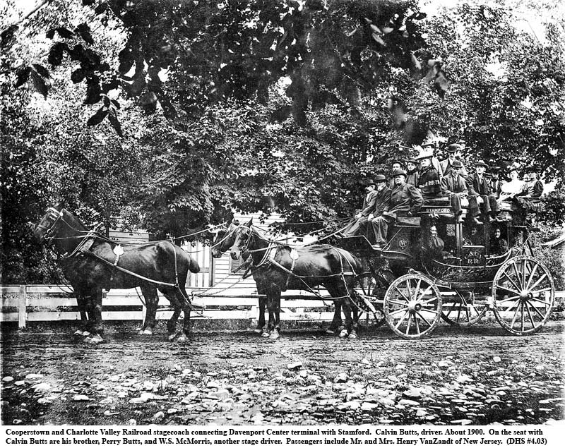
First stagecoaches, then a train from Stamford. While the Delaware Otsego Railroad (after 1902 consolidated into the Ulster and Delaware) remained at a standstill in Bloomville, a connection of sorts was made with Davenport and Oneonta. This was accomplished by running a Tally-Ho stage line between Bloomville and Davenport Center to connect with the new C. & C. V. Railroad from Colliersville.[58] The stage began in 1891 and ended with the arrival in Davenport Center of the Ulster and Delaware in 1900.[59] The 15-mile ride must have provided a good workout for the horses as they climbed over 600 feet in nine miles to Kortright Station and then dropped about 400 feet to Bloomville.[60] A second Tally-Ho line, between Davenport Center and Stamford, was announced on June 15, 1895. (See the earlier picture of this stage.) This line, while a few miles longer than the one to Bloomville, gave faster access to Stamford for rail connections to Kingston, New York and, in the reverse direction, from Stamford to the west and to the north as far as Utica and to the resort town of Richfield Springs. There was also at this time a Tally-Ho connection between Davenport Center and Oneonta.
Despite their demise elsewhere, the 30-mile section of the old Charlotte Turnpike between Oneonta and Stamford continued to see horse-drawn stages until at least 1920. (See photo 4f at the end of the chapter.)
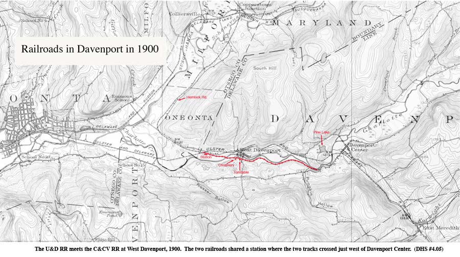
When the Ulster and Delaware (still named the Delaware Otsego) finally reached Davenport Center in 1899, it did not connect with the Cooperstown and Charlotte Valley Railroad. Instead it crossed Charlotte Creek and then followed the north bank to Davenport Center where it shared a station with the C. & C. V. “A mile west of there the U. & D. grade crossed the C. and C. V. tracks, the Charlotte Creek and the Susquehanna by means of two steel bridges.”[61] (See map.) The new railroad had an immediate effect on the economy of Davenport and East Meredith. Until this time most farmers made butter, but milk was often wasted or fed to chickens. A few cheese factories existed, but the railroad meant faster transportation to big-city markets that were eager for fresh milk and other foodstuffs. Sheffield Farms, which had a previous creamery at Davenport, now built facilities at Davenport Center and further up the line near Kortright Station. Workmen cut ice in Strader Lake (later Sherman and now Pine Lake) and packed 200 pound cakes of ice in sawdust to provide cooling for dairy products during warm weather. \MAP Ulster & Delaware RR Meets the Cooperstown & CV RR…\
Hotels in New York City ordered tubs of butter made in the new creamery, but they canceled their orders the following week. Customers were not yet accustomed to the difference in flavor between the creamery butter and that made by the farmers which was saltier and stronger. It was a matter of customer education and it didn’t occur overnight.
The U. &. D. reached Oneonta in July 1900. The Delaware and Hudson took over the C. & C. V. in 1903 and dropped passenger service to Davenport Center.[62] The Ulster and Delaware was bought by the New York Central and became the latter’s Catskill Mountain Branch in 1932. Service steadily diminished to only one train a day by 1950.[63] The last U. & D. passenger train left Oneonta on April 1, 1954, though limited freight service continued.[64]
The Ulster and Delaware had once been an economic lifeline for the dairy farmers of Delaware County. Gerald M. Best, riding eastward in 1946, saw his train pulling fourteen boxcars of milk cans out of the Arkville station on their way to Kingston.[65] Better highways and refrigerated milk trucks eventually brought an end to the railway age in dairy country. The U. & D. petitioned to abandon the Oneonta-Bloomville section in 1963, and the last freight train was seen in Davenport Center in 1967.

The following additional illustrations to be found here.

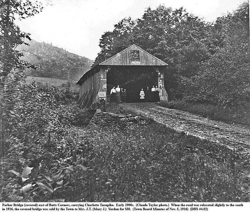
| 4a | Parker Bridge (covered) over Middle Brook near Davenport’s eastern boundary. |
| 4b | Parker
Bridge interior, showing construction, early 1900s |
| 4c | Turntable
for engines of C&CV Railroad, West Davenport |
| 4d |
C&CV RR alongside Charlotte meeting turnpike’s covered bridge, Davenport
Center |
| 4e | Last
passenger train of former U&D Railroad to pass through West Davenport, 1954 |
| 4f |
Two-horse stage with driver Orson J. Buck, Davenport Center |
[1] “The travel along… the Charlotte, just above the junction of the two streams.” (Munsell, 1880, 144.)
[2] Many Indian trails crisscrossed the Catskills. Among those pointed out in his History of Schoharie County, New York, William E. Roscoe [p. 153] refers to a trail along the West-kill in the Town of Summit that the Indians followed on their trips to Summit Lake and the Charlotte River. “During the Revolution it was frequently traversed by them with captives…” (Kubik, 2001, 24.)
[3] On Gray’s map, the trail begins at the Upper Fort on the Schoharie (the present Fultonham). It then follows (on the map) a nameless stream to a nameless lake (almost certainly Summit Lake), then drops down to “Lick Run,” a Charlotte River tributary, and thence on to the place of Joseph Bartholomew, Servoss’ Gristmill, and the Canoe Place, all on the Charlotte. (New York Historical Society in Hinman, 1975.)
[4] One later analyst…located near the current Braehead Hill road in Kortright. (Mathews, 1965, 29.)
[5] Certainly this last section… between Fergusonville, Butts Corners and Bloomville. (Mathews, 1965.)
[6] The feat was accomplished by damming Otsego Lake at its outlet and then placing boats and canoes below the dam. Clinton’s troops then waited for the lake to rise, broke the dam, and rode the flood downstream that first day to an area now covered by Goodyear Lake. (Hinman, 1975, 68-72; Kelsay, 1984, 256; and others.)
[7]In 1787 the state legislature decreed… roads ‘to the extent of two rods [32 feet] at least.’” (Monroe, 1949, 88.)
[8]Each county was to have one commissioner and each town, three. (Kubik, 2001, 14-15.)
[9]Wagon roads… in 1801 the legislature specified that at least half… before the first day of July. (Kubik, 2001, 15.)
[10] On March 1, 1794, John Jacob Astor and William Laight, both merchants in New York City, acquired for 8,000 pounds that part of the Charlotte River Patent still unsold at Sir William Johnson’s death, 22,782 acres. (Otsego County deed C.A.G, Liber B, cp. 329; notes copied by Howard Fletcher Davidson, 1978.) Two weeks later, these two sold a part of their shares for 4,000 pounds to Peter Smith, “merchant, of German Flats, Herkimer County.” This left Astor and Laight with a ¼ share each and Smith with one-half. (Deed dated March 15, 1794, proved March 15, 1794, Liber B, cp. 332, Otsego County; also from H. Fletcher Davidson.)
[11]By 1806, a later study revealed… only 35% of all proposed and planned roads would be completed. (Kubik, 2001, 27.)
[12]“By an act passed April 6, 1790,… present tract of communication now between said rivers.” (Monroe, 1949, 89.)
[13] Sluman and Nathaniel Wattles…the new town’s leading citizens. (Kubik, 2001, 40; Munsell, 1880, 168-171.)
[14] Nathaniel Wattles and Medad Hunt contracted for 680 pounds… as far as Stamford by 1792. (Monroe, 1949, 89.)
[15] …Turnpike Company was formed in 1800. (Both Sluman Wattles… were charter members… ) (Kubik, 2001, 28.)
[16] In the following year… not finished until sometime between 1803 and 1806. (Kubik, 2001, 42-7.)
[17] “In 1805… the road was wholly in operation and was paying five percent on the stock.” (Monroe, 1949, 89.)
[18]Franklin, when the Catskill-Susquehanna Turnpike was begun, bordered the Susquehanna between Unadilla and today’s Sidney almost all the way northeast to Oneonta. The part that included the mouth of the Ouleout was taken off for Sidney in 1801. In 1822 the section along the Susquehanna River nearest to the village of Franklin was transferred to Otsego County and the new town of Huntsville, later Otego.
[19] The Town of Franklin … more than tripled… a further ninety percent in the next ten years. (All population figures are from photocopies of original federal census returns in the files of the Davenport Historical Society.)
[20] Except for 1790 these estimates, as noted elsewhere (Chapter 3 and 15), attempt to include residents in Davenport’s section of the Fitches Patent (once in Maryland) and to exclude those later lost to southside Oneonta.
[21] “Probably no one anticipated… and free passage to those with twelve-inch wheels… narrow ones.” (Kubik, 2001, 24.)
[22] In 1803… following the probably even cruder trail up the Charlotte River to Kortright. (Kubik, 2001, 13.)
[23] On McCalpin’s 1808 map… but that road, like so many others, was never built. (Kubik, 2001, 22.)
[24] Although referred to at the Oxford Turnpike by some, such as Nicolas Sigsbee below, the April 16, 1839, charter authorized construction only as far as Gilbersville, about half way to Oxford. (Campbell, 1906, 88-9.) The westernmost, Gilbersville-Oxford section of the turnpike was never completed.
[25] Ford wanted the new road… built in the summer of 1834 by one White of Prattsville.” (Sigsbee, 1889a.)
[26] It hastened the demise of the Susquehanna Turnpike… Cherry Valley…and then to Albany. (Kubik, 2001, 88-9.)
[27] “White employed about twenty men… the whiskey boy, that carried it around.” (Sigsbee, 1889a, September 12.)
[28] Davenport’s 1820 and 1830 population estimates, once again, have been approximately adjusted to exclude those persons lost to Oneonta somewhere between 1822 and 1835 but counted as Davenport residents in both the 1820 and 1830 federal censuses.
[29] Davenport’s population rose… between 1820 and 1830 and by only 5 percent from 1830 to 1840.) (Strout, 2002, 9).
[31] (The alternative stage route up the Mohawk Valley… did not reach Niagara until 1812.) (Kubik, 2001, 59)
[32] “I can scarcely conceive… After Meredith the country “lost its beauty.” (Monroe, 1949, 90-1.)
[33] In 1825 “a coach left Catskill for the west every day but Monday.” (Monroe, 1949, 99.)
[34] Farmers “with their wagons… competing with stagecoaches for a place on the turnpike.” (Kubik, 2001, 73.)
[35] (The hamlet of East Davenport had a twice-weekly… as early as 1829.) (From testimony of Asahel Miriam, mail carrier, at the probate of John Davenport’s will. Surrogate Court records, Delaware County Courthouse, Delhi, N.Y.)
[36] Sidebar: Turkeys could walk four miles a day… with pine tar to help protect against soreness. (Kubik, 2001, 76.)
[37] Sidebar: Certain taverns… would be located at some distance from the local village. (Kubik, 2001, 82.)
[38] Sidebar: The turkeys of the early 19th century… you could walk them to Alaska.” (Peter DeMarco, “Traffic foul-up,” Boston Globe, Nov. 27, 2002, pp. B1, B6.)
[39] By 1837 it was twice a week, at least on some sections. (Monroe, 1949, 98-9.)
[40] David Boswick and others… Any competitors would be fined $50. (Kubik, 2001, 68; Monroe, 1949, 90.)
[41] It may not have been until 1820 that the much larger… on the Catskill-Susquehanna turnpike. (Monroe, 1949, 98.)
[42] In 1891, Jessie Haynes… horse’s head to complete the job. (Taped interview with Mr. and Mrs. Jessie Haynes, January 23, 1968; Davenport Historical Society.)
[43] Smaller, two-horse coaches…eventually disappeared from the roadways. (Monroe, 1949, chapter V.)
[44] “A great deal of liquor… at these old distilleries.” (Munsell, 1880, 177-8.)
[45] “The turnpike made the taverns… because it could not have fulfilled its purpose without it.” (Kubik, 2001, 84.)
[46] The mid-1800s were rife with proposals and rumored proposals for railways in the Catskills and nearby areas. The exact route of each proposed road may have been left intentionally vague to learn which potential communities could drum up the most enthusiasm and promise of financial support. Plans for the Albany and Susquehanna Railroad were welcomed by the Bloomville Mirror as early as June 1, 1852. “[T]he pretty clearly settled” and the “most feasible route” would be to pass through Bloomville, then up Wright’s Brook and then “down the Briar Street [East Meredith] road to Davenport Centre…” (This was indeed the route followed by the later Ulster and Delaware Railroad.) Davenport in the 1858 voted to raise $30,000 to support the A.& S. (See DHS document GVRR 001-027; whether any funds actually materialized is not known) and its first Commissioners of Rail Road (1861-65) were appointed to oversee the prospective Albany and Susquehanna Railroad.
[47] John Westover … J. Pierpont Morgan and James Rosevelt [sic] of New York City. (Hurd, 1878, 42.)
[48] The original routing… rather than down the Charlotte Valley. (This account is from Davenport lawyer Walter Scott in Murray, 1898, p.335.)
[49] This began as the Roundout and Oswego Railroad, chartered in 1866… (The following section draws heavily on Gerald M. Best, The Ulster and Delaware; Railroad Through the Catskills, San Marino, California: Golden West Books, 1972.)
[50] This began as the Roundout and Oswego Railroad... connect with the Albany and Susquehanna. (Best, 1972, 19, 21.)
[51] The last record of… William (“Uncle Billy”) McDonald in 1875. (Town Board Minutes, November 4, 1875.)
[52] Meanwhile, a controversy… Lawsuits followed, to be lost twice by Harpersfield. (Best, 1972, chap. 7.)
[53] A new company, the Delaware Otsego Railroad, was created in 1887… past Stamford. (Best, 1972, 93.)
[54] A timetable issued the next January… to turn around the engines. (Stamford Mirror, January 11, 1890, p. 1.)
[55] The train was turned manually on a turntable in West Davenport and then backed up to the Davenport Center terminal located on Lot No. 39, bounding the later Harry Briggs property.
[56] The Cooperstown and Charlotte Valley Railroad… into Harpersfield township…” (Best, 1972, 95.)
[57] A Tally-Ho was a large, four-in-hand (four horses driven in two teams by one person) stagecoach, named for a fast coach, “The Tally Ho,” which once had plied between London and Birmingham.
[58] This was accomplished… connect with the new C. & C. V. Railroad from Colliersville. (Best, 1972, 110.)
[59] The stage began in 1891 and ended with the arrival… of the Ulster and Delaware in 1900. (Best, 1972, 110.)
[60] The 15-mile ride… then dropped about 400 feet to Bloomville. (Best, 1972, 170.)
[61] “A mile west of there… and the Susquehanna by means of two steel bridges.” (Best, 1972, 109.)
[62] The U. &. D. reached Oneonta… and dropped passenger service to Davenport Center. (Best, 1972, 110.)
[63] The Ulster and Delaware was bought…diminished to only one train a day by 1950. (Best, 1972, 164-5, 178.)
[64] The last U. & D. passenger train… limited freight service continued. (Davenport Historical Society Scrapbook, SCR-II, p. 3.)
[65] Gerald M. Best… milk cans out of the Arkville station on their way to Kingston. (Best, 1972, 175.)